Greater Los Angeles wildfires impacted by meteorological misfortune

The Palisades fire burning in Los Angeles County can been seen in this NASA satellite image. Photo courtesy NASA Earth Observatory
Editor's note: This is a quickly changing situation. The information in this article was accurate as of time of publication.
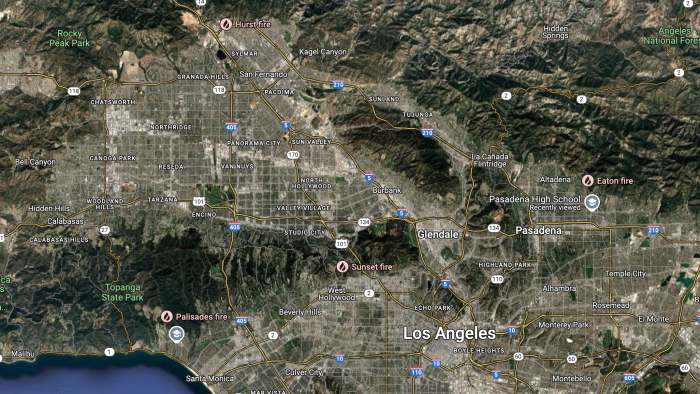
Los Angeles County is in peril as multiple wildfires have blazed through the region in the last several days, burning thousands of homes and other structures, leaving hundreds of thousands of people still without power Thursday morning, and forcing nearly 180,000 people to evacuate their homes.
Fast sweeping flames have been pushed by the Santa Ana winds, and blazes have broken out in places such as Pacific Palisades, Hollywood Hills, Pasadena, Altadena, Malibu and Santa Paula.
The wildfires are fast-moving, wildly unpredictable and there has been little containment. At least five people are dead, with the death toll expected to rise, and dozens are injured. Los Angeles County has declared a state of emergency and officials are warning the worst is yet to come.
Looking for answers as to how such an intense fire could break out this time of year, ASU News turned to Randall Cerveny, a President’s Professor in the School of Geographical Sciences and Urban Planning, where he has taught since 1986.
Cerveny serves as rapporteur on extreme records for the United Nations and World Meteorological Organization, and is also responsible for researching and verifying global weather records.
He said the gusty Santa Ana winds, dry air and drought conditions are responsible for these wildfires, but climate change will increase the frequency of such occurrences.
Question: Fires in Southern California are not new, but historically this appears to be more inland than I seem to ever recall. How do you account for this?
Answer: Actually, they are not. As with most Santa Ana-generated fires, these are primarily coastal fires. The fires are primarily the result of the incredibly strong downslope winds, called Santa Ana winds. They were created by the same pressure system — a very strong high-pressure system — that gave us the strong winds here in Arizona at the same time (Jan. 7 and 8).
The high-pressure system is in Utah with a smaller low-pressure system down in northern Mexico. Air around a high-pressure system turns clockwise, so the winds were spun down from Utah through Arizona — drying them out more. The winds were then pushed eastward into California … where they were compressed and pushed down through gaps in the coastal mountains. The gaps mean that the winds are funneled through passages and accelerated, like putting your finger over a water hose. The net result is a very dry, very strong wind. In the fall, Santa Ana winds are also very hot, but because of the current time of year — winter — these Santa Ana winds were only mild in temperature, not oppressively hot.
However, it must be remembered that the winds themselves cannot cause wildfires. It also takes some external ignition such as downed power lines or someone personally igniting the brush.
Q: What are the factors that have made these specific fires so devastating?
A: The specific immediate causes of this current set of wildfires are: A. The very strong high-pressure cell located over Utah; B. A transitive low-pressure system working its way across northern Mexico and southern Arizona — it is the difference in pressure between the incredibly strong northern high-pressure system and the southern low-pressure system that produces the incredibly strong winds; and C. Something to cause the ignition, such as downed power lines or, regrettably, someone personally setting them.
However, there are also long-term influencing factors to this set of wildfires as well. The situation is worsened because of the severe long-term — now two decades-long — drought affecting the entire Southwest. The drought causes the vegetation to dry, and that vegetation then becomes a "perfect fuel" for the creation of long-scale wildfires. Across the Southwest, we are having many more wildfires in current times than we did in the past in part due to long-term drought.
Second, the strength of high-pressure systems over the last few decades has been intensifying as a result of long-term climate change. Stronger high-pressure systems can produce stronger Santa Ana winds. Both of these secondary factors have unfortunately aided in this current wildfire situation.
Q: Normally Santa Ana winds tend to occur in the fall. Why are they occurring now in the wintertime?
A: This wintertime occurrence has set up in part due to the long-term drought and dryness over the Southwest. Moisture holds on to heat energy. If we don’t have moisture in the air — and it has been very dry over the entire Southwest — then that heat energy normally in moisture is used to create stronger and stronger winds. Most people in Arizona noticed that this summer we didn’t have very many intense thunderstorms. Instead, the heat energy that normally would go to creating such storms was used to produce very strong winds. Unfortunately, weather systems that don’t produce clouds and rain will instead create strong winds. That is the situation that is currently occurring over the Southwest. Storms simply don’t have enough moisture to create clouds and rain/snow.
Interestingly, as the current weak, low pressure moves out of northern Mexico into the Great Plains and East, it actually will likely cause significant severe weather and even blizzard conditions as it picks up that critical moisture from the Gulf of Mexico.
Q: As the homes and neighborhoods that have burned to the ground will need to be replaced, what should the city or developers take into account as they build for the future?
A: We must plan for an increased occurrence of this type of event. That means that continual dryland landscaping as well as building location and maintenance must be done with an overall idea that this type of event can — and will — occur. Over the past few decades, we have learned that protection of life and property can be undertaken ahead of these events.
One of the great things about ASU is that through the Global Futures and sustainability initiatives that the university is undertaking, we are training students — who eventually will become city managers and first responders having to handle these situations — to better prepare and plan for such events.
Q: What does recovery from this type of event look like?
A: The response isn’t a climatic situation; it is a human situation. The ability for recovery is directly linked to the governmental authorities in power having the ability and the willingness to address both short and long concerns to disaster situations. Often, the long-term concerns, such as firm rules and guidelines for building and landscaping, are harder to get implemented.
Those long-term concerns can be a problem because, from a climate perspective, I can tell you that the overall situation will continue to get worse. And if long-term concerns are not addressed, we simply lurch from one crisis to the next, addressing only short-term response.
Why will the situation continue to get worse? Because with the long-term drought and with climate change acting in the background, the frequency of such occurrences will increase. In other words, we will have more and more of these wildfire events across the entire Southwest in the future.
More Environment and sustainability

ASU-led collaboration receives $11.2 million to build Southwest Regional Direct Air Capture Hub
Arizona State University and a team of its collaborators have received $11.2 million in funding from the U.S. Department of Energy to begin developing a regional Direct Air Capture Hub for removing…

A water fix that takes on the yuck factor
Written by Christy Spackman, an ASU assistant professor and senior global futures scientist. This essay is adapted with permission from an article in Issues in Science and Technology from her book, “…

At home in the wild
By Kristin ToussaintEditor's note: This story is featured in the winter 2025 issue of ASU Thrive.Way up in the Andes mountains in Colombia, wax palms stretch their towering, skinny trunks into the…

