How complexity science can guide urban transformations: Lessons from Germany

Shade Shudders
Complexity science, which describes how complex systems actually function in reality, can be leveraged to help cities worldwide navigate disruptions, whether due to energy policies, natural disasters or simply reconfiguring local economies for a brighter future.
A discussion held on March 29 by Arizona State University's Consortium for Science, Policy and Outcomes, or CSPO, delved into the lessons America can learn from countries like Germany, which has seen impressive success by integrating innovative technology into urban development decision-making.
The discussion included Bastian Alm, head of the Germany Ministry for Economic Affairs and Climate Action, and Shade Shutters, a research scientist for the School of Complex Adaptive Systems within ASU’s College of Global Futures.
During the panel’s opening remarks, CSPO Director Arthur Daemmrich highlighted some of the complicated history of urban renewal, and how well-intended projects can harm communities and economies when not planned mindfully.
“Even as awareness of field approaches has grown … how to get the mix of design, engineering and the social dimension of urban renewal right remains quite contested,” Daemmrich said.
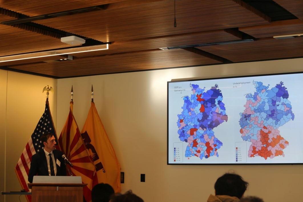
Germany is a case study of conscientious urban planning, and its use of regional structural policy is designed to support social stability for their citizens. Current regional disparities in productivity, income and employment pose challenges for urban development decisions within Germany, with Southern Germany experiencing unemployment rates of 2% to 4% and some regions in Northeastern Germany experiencing unemployment rates of 14% to 16%, Alm said.
As the country mitigated differences across regions, it analyzed productivity and employment data visually through a data map model that displayed the strengths and weaknesses of different regions.
The model used productivity, underemployment, workforce projection and infrastructure quality of each region in a “rules-based approach to designate assistive areas,” Alm said. “We actually tried to define structural weakness in terms of competitiveness, referred to at an average value by using an indicator model.”
The model can then be used to make educated decisions on what programs and funding will best suit a specific region.
According to Alm, one of the more important programs that Germany is currently implementing to create more stability is the Länder Task for the Improvement of Regional Economic Structures, a joint program between the German federal government and states. The program has funded 5 million jobs and more than 150,000 projects. Germany’s structural policies also support the country’s broader goal of being climate neutral by 2045, including proposed initiatives like phasing out coal mining by 2038 and reallocating jobs and resources of that region elsewhere.
Shutters explained how America could benefit from learning how Germany has handled their regional transition.

Bastian Alm, a senior leader in the Germany Ministry for Economic Affairs and Climate Action, speaks at a panel hosted by Arizona State University’s Consortium for Science, Policy and Outcomes.
“I was interested in the problems in Germany of the regions that are suffering from having their coal mines closed as part of Germany’s national energy transition,” Shutters said. “I think we can take lessons from a country going through a transition, learn from those and bring them back here when we get serious about our own energy transition.”
Shutters works in ASU’s Laboratory for Regional Dynamics and Development and has been optimizing data visualization to better manage the structure of urban economies.
“We still use the same underlying information, but we apply techniques from information theory, network analysis, even evolutionary theory to get a fuller picture of a region’s economic structure, including how particular industries within a region depend on each other,” Shutters said.
Shutters showed examples of data maps, each displaying a colorful myriad of points representing the economic structure of a region. In this visualization technique, Shutters can locate not just urban areas, but industries, and measure the distance between the two.
“What we use as a map of an economic structure is not a distribution or some graph; it’s an actual complex, weighted network that changes over time,” Shutters said.
In urban planning, this can help an area decide its measure for suitability, or its potential for new jobs and economic success. Shutters and his colleagues use this tool to present the factor of suitability to policymakers in different areas in hopes that regions can intuitively create sustainable jobs.
“These types of tools are really important to get people back to work and revitalize regional economies before they deteriorate,” Shutters said.
While extremely helpful to conversations on urban transformations, current data visualization tools only show one piece of economies, according to Shutters. He hopes to one day create a data visualization tool that layers multiple dimensions of each area’s economy to better inform policy decisions.
John Cloud from the Smithsonian Institution’s Arctic Studies Center, who attended the event, asked Alm and Shutters how data visualizations will address ecological functions like pollution.
Both Alm and Shutters reinforced that, while the data maps focus more on economy, overarching programs in the region and direction from analysts can help support ecological policy.
For example, Germany’s approach includes their overarching goal of climate neutrality by 2045. Their current actions are “a new approach to somehow combine industrial and structure and climate policy,” Alm said. “I agree that in the past this was not the focus of our programs, but now we try to be open to this combination of specific aspects to reach our climate goals.”
Shutters added that when his team presents data to stakeholders, they sometimes include carbon footprint as a factor in their presentation for them to make the most informed decision that advances both urban development and the region’s ecological goals.
An online attendee asked if Alm or Shutters had considered the possibility that such tools could create increased polarization between the people who create the tools and the communities they address.
“I don’t use this tool to make a decision,” Shutters said. “It’s only to give as much information as possible to the stakeholders that do; I’m very transparent about what the data is, where it comes from and how I’ve used it.”
When addressing policymakers with suggestions, it’s key to “learn what their problems are before you march in and tell them you're going to change the world for the better,” Shutters said. “If you don't have humility, you're not going to get past the front door oftentimes.”
More Law, journalism and politics

'Politics Beyond the Aisle' series to explore the stories of public officials
In an effort to build a stronger connection between students and political and civic leaders, Arizona State University’s School…

ASU committed to advancing free speech
A core pillar of democracy and our concept as a nation has always been freedom — that includes freedom of speech. But what does…

ASU experts share insights on gender equality across the globe
International Women’s Day has its roots in the American labor movement. In 1908, 15,000 women in New York City marched to protest…

