Alaskan coast 8.2 magnitude earthquake recorded by ASU seismometer

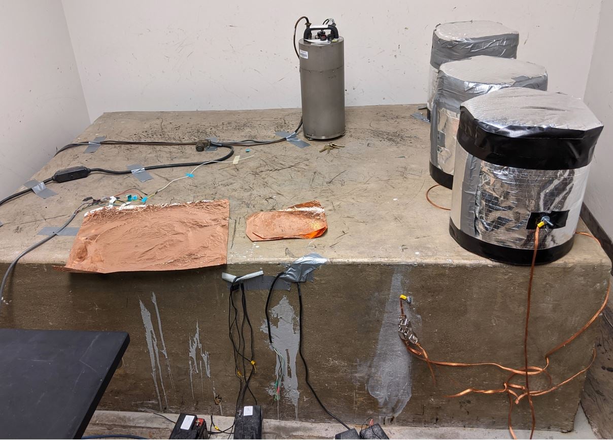
Close-up of the Guralp CMG-3T broadband seismometer, topped with the Guralp DM-24 signal digitizer. Keys are included for scale. The digital signals from this combination are recorded on a nearby desktop PC. Credit: West/ASU
The 8.2 magnitude earthquake that struck off Alaska’s coast on July 28 was the strongest earthquake in the area since 1964 and generated tsunami warnings for the coastal areas of south Alaska, the Alaska Peninsula, and the Aleutian Islands. According to the U.S. Geological Survey (USGS), the strong quake was located about 56 miles (90 kilometers) east-southeast of Perryville, Alaska, and was 29 miles (46.7 km) deep. Earthquakes are known to occur at any depth from right at the Earth's surface to approximately 430 miles (700 km) down.
While the tsunami is no longer a threat, seismometers all over the world recorded this quake, including one located in the basement of a building on the Arizona State University Tempe campus. The data on the quake is displayed on a new ASU website: earthquake.asu.edu.
More: ASU-recorded data on earthquakes
This seismometer and corresponding website are managed by ASU geophysicists John West and Edward Garnero of the School of Earth and Space Exploration. The public site provides information on earthquakes and seismic activity from anywhere in the world as measured at ASU, compiling earthquake information provided by the USGS, including magnitude, latitude, longitude and depth, and then calculating the distance of the earthquake from ASU.
“The ASU seismometer was set up as a reference instrument to support our long-running series of projects to develop a planetary exploration seismometer for NASA,” said West. “Once it was set up and recording full time, it made sense to make the output available to the public.”
Seismometers are designed to be sensitive to the motions of the Earth and can detect earthquakes, volcanic eruptions and explosions. The ASU seismometer is a broadband Guralp model CMG-3T sensor and includes three weights suspended by precision springs.
When the ground moves from an earthquake, the seismometer case moves with the ground motion but the suspended weights, by inertia, initially do not. The seismometer then records the motion of the instrument around the weights in north-south, east-west and up-down directions.
“This is a very sensitive instrument,” said West. “It can record a motion as small as one-fiftieth the diameter of a human hair.”
The ASU seismometer is located in the basement of the Bateman Physical Sciences Building F-Wing on the ASU Tempe campus, which was specifically designed to accommodate a seismometer. Builders installed a vertical concrete column projecting 40 feet into the subsurface below the basement and equipped the column with rubber gaskets to help isolate it from building vibrations so the seismometer could more distinctly measure vibrations from earthquakes.

The Guralp seismometer on the concrete seismic pier in the basement of Bateman Physical Sciences building F-wing. The pier is vibrationally isolated from the building and extends approximately 40 feet below the basement floor. Canisters on the right provide electromagnetic and thermal isolation for testing new sensors. Credit: West/ASU
“Our seismometer provides information on how earthquakes register in Tempe specifically,” said West. “We intend to provide a local view of these global events.”
In addition to information on the most recent earthquakes, visitors to the website can also learn about historical earthquakes and fault locations in Arizona and sign up for earthquake e-mail alerts on newly detected and plotted earthquakes.
More Science and technology

Indigenous geneticists build unprecedented research community at ASU
When Krystal Tsosie (Diné) was an undergraduate at Arizona State University, there were no Indigenous faculty she could look to…

Pioneering professor of cultural evolution pens essays for leading academic journals
When Robert Boyd wrote his 1985 book “Culture and the Evolutionary Process,” cultural evolution was not considered a true…

Lucy's lasting legacy: Donald Johanson reflects on the discovery of a lifetime
Fifty years ago, in the dusty hills of Hadar, Ethiopia, a young paleoanthropologist, Donald Johanson, discovered what would…