NSF-funded, ASU-led research network tackles flood justice

In 2017, members of the South Carolina Helicopter Aquatic Rescue Team performed rescue operations to assist those affected by the epic rainfall from Hurricane Harvey in Port Arthur, Texas. Photo courtesy of U.S. Air National Guard by Staff Sgt. Daniel J. Martinez.
Like many environmental risks, flooding exacerbates preexisting social inequalities, with marginalized communities often bearing the brunt of its impact.
In a groundbreaking effort to address those complex interactions, Arizona State University was recently awarded a significant grant from the National Science Foundation to establish the Research Coordination Network (RCN), focused on flood justice.
This network aims to unite researchers, policymakers and community voices to advance resilience strategies and address injustices faced by flood-prone communities across the United States.
Current research on flood inequities is often fragmented across disciplines, using varying methods, datasets and terminology. Community organizations and residents in flood-affected areas are frequently excluded from research and decision-making.
The RCN’s collaborative network intends to synthesize this diverse knowledge and develop solutions addressing social inequalities that contribute to unequal flood risks and recovery outcomes. This initiative aims to improve flood risk measurement, understand the long-term socioeconomic impacts of floods and ensure that flood mitigation policies promote social equity and resilience in affected communities.
Led by Aaron Flores, assistant professor in the School of Geographical Sciences and Urban Planning (SGSUP), the network will involve steering committee members from various institutions, including Stanford University and the U.S. Army Corps of Engineers, along with community organizations.
To gain deeper insights into the RCN's objectives and the broader implications of flood justice, we spoke with Flores about his perspectives.
Question: What is flood justice?
Answer: Flood justice refers to the equitable management of flood risks, ensuring that all communities — regardless of race, income or other social characteristics — have equal protection from environmental hazards and equal access to decision-making processes. It emphasizes the importance of involving affected communities in shaping solutions so their voices are heard and their needs addressed. Similar to environmental justice, it seeks to create fair, inclusive policies that protect everyone equally from the negative impacts of floods.
Q: Where have we seen this throughout history?
A: The idea of flood justice gained significant attention after Hurricane Katrina in 2005, which unevenly affected people of color and those with lower incomes who lived in areas more vulnerable to flooding and had fewer resources to recover.
Historical events such as the 1927 Mississippi River Flood and the 1948 Vanport Flood in Portland (Oregon) underscore long-standing racial and socioeconomic disparities in flood impacts. Since at least the 1940s, geographers have been paying attention to and researching social vulnerability related to flooding.
Q: Is it getting worse?
A: Research on major flood events consistently reveals that marginalized communities face greater risks, longer recovery times and are less prepared for such disasters. This was evident during Hurricane Harvey in 2017, when communities of color and low-income households in Houston were disproportionately affected by the flooding. Similar inequalities are likely to persist in the aftermath of more recent storms, such as hurricanes Helene and Milton, as we observe the uneven distribution of flood impacts.
Q: What inspired you to take on a leadership role in the RCN?
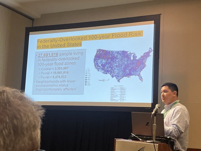
A: My expertise lies in the environmental justice aspects of flooding. I have conducted extensive research showing that marginalized populations are disproportionately affected by flood events, such as Hurricane Harvey, and are often located in high-risk flood areas that are not recognized by federal flood risk maps.
The idea for this network culminated from discussions with SGSUP alumna Beth Tellman, an assistant professor in the Department of Geography, Development and Environment at the University of Arizona, along with her Social[Pixel] lab and others involved in flood justice work. The idea was inspired by the 2023 Flood Justice Symposium at the University of Arizona, which several of the co-investigators attended, and we all wanted to keep this valuable exchange going.
Q: What strategies will the RCN implement to foster collaboration?
A: We will promote collaboration through interactive workshops focused on data synthesis, risky urban development and co-producing flood risk futures. These workshops will bring together researchers, policymakers and community organizations, facilitating knowledge exchange through hands-on activities, case studies and panel discussions that prioritize diverse community perspectives. Community input will be vital in co-designing research projects to ensure solutions meet local needs.
Additionally, we will engage with the Bill Anderson Fund (BAF) Fellows — underrepresented graduate students in hazards and disasters research across 30 U.S. institutions — and plan to participate in the BAF Fall Workshop hosted by ASU every other year.
Q: How do you envision the RCN influencing future flood mitigation policies and practices?
A: By improving our understanding of flood exposure and outcomes — especially for marginalized communities — we plan to create a harmonized flood data dictionary. Satellite imagery and surveys will enable policymakers to better assess localized risks and inequities. We believe this will provide a more accurate basis for developing policies that promote social equity and resilience, ensuring that recovery funds, infrastructure investments and risk communication strategies more effectively serve the most vulnerable communities.
More Environment and sustainability

Rethinking Water West conference explores sustainable solutions
How do you secure a future with clean, affordable water for fast-growing populations in places that are contending with unending drought, rising heat and a lot of outdated water supply infrastructure…

Meet the young students who designed an ocean-cleaning robot
A classroom in the middle of the Sonoran Desert might be the last place you’d expect to find ocean research — but that’s exactly what’s happening at Harvest Preparatory Academy in Yuma, Arizona.…

From ASU to the Amazon: Student bridges communities with solar canoe project
While Elizabeth Swanson Andi’s peers were lining up to collect their diplomas at the fall 2018 graduation ceremony at Arizona State University, she was on a plane headed to the Amazon rainforest in…